
From Surveyor’s Chains to Property Lines: A Look at Central New York’s Real Estate History
When we think about real estate today, we tend to think about listings, deeds, tax maps, surveys, boundary lines, and closing documents. But the process of defining and transferring land in Central New York has a history stretching back centuries.
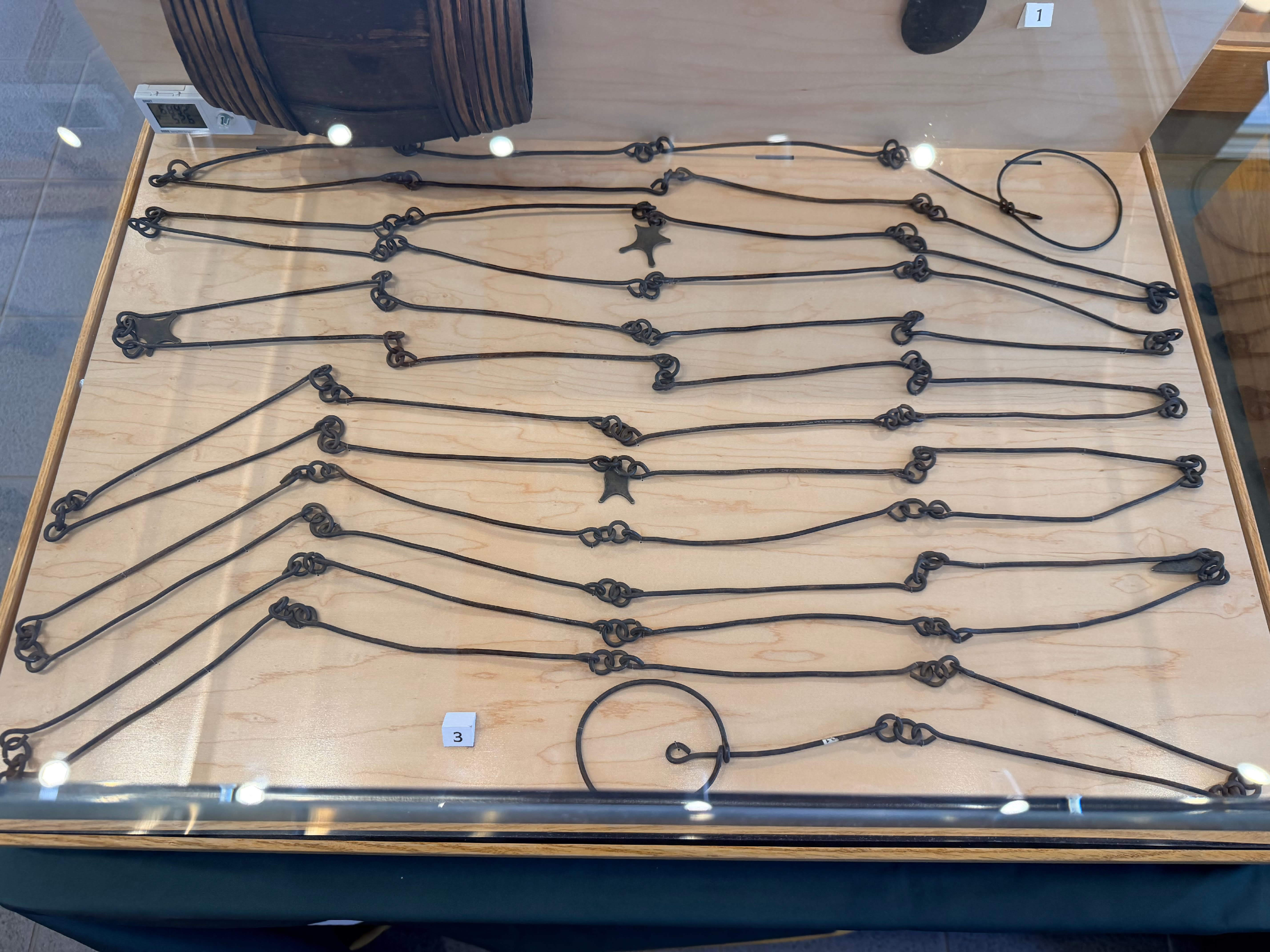
The surveyor’s chain pictured here, which belonged to Brigadier General James Clinton, offers an interesting connection between the history of our region and the way property was eventually divided, mapped, and settled.
Dating to approximately 1725, the chain is part of the museum collection at Washington’s Headquarters State Historic Site and the New York State Office of Parks, Recreation and Historic Preservation.
Surveying Central New York in the 1700s
During the Revolutionary War, Generals John Sullivan and James Clinton led the 1779 Sullivan-Clinton Campaign into the traditional territory of the Haudenosaunee, or Iroquois Confederacy. Surveyors accompanied the military expedition, recording and examining portions of the landscape as they traveled.
The campaign was devastating to many Haudenosaunee communities, destroying villages, crops, and food supplies. Its aftermath also contributed to the displacement of Native people from lands that New York State would increasingly claim and distribute to others.
Following the war, large areas of Central New York were surveyed and divided into parcels. Land grants were then used to compensate Revolutionary War veterans for their service.
Many of the earliest non-Native settlers throughout Central New York and the Southern Tier were veterans of the Revolutionary War era.
That history played an enormous role in shaping the communities we recognize today.
Why a Surveyor’s Chain?
Before GPS equipment, electronic distance meters, drones, and modern surveying instruments, measuring land required considerably more physical work.
One of the principal tools was the surveyor’s chain.
A traditional surveying chain consisted of linked pieces of metal of a carefully standardized length. Surveyors would physically stretch the chain across the landscape, measuring distances one chain at a time. Combined with compass bearings and field notes, those measurements allowed surveyors to establish boundaries and eventually create maps.
It was demanding work. Imagine attempting to establish straight property lines through forests, hills, streams, swamps, and rocky terrain without any of the technology available to surveyors today.
Yet those early measurements helped establish some of the property boundaries, roads, lots, towns, and settlement patterns that influenced the development of Central New York.
Surveying Still Matters in Real Estate
More than two centuries later, surveying remains an important part of real estate.
Property boundaries aren't always as obvious as a fence, hedgerow, driveway, or lawn might make them appear. A survey can help establish the location of a property's legal boundary and identify features such as buildings, easements, rights-of-way, encroachments, and other improvements.
This can be particularly important when dealing with the types of properties we frequently see throughout Central New York: large acreage parcels, farms, rural homes, vacant land, wooded recreational property, and older properties whose boundaries may have been established generations ago.
Modern surveyors have technology that James Clinton's generation could never have imagined, but the underlying objective remains remarkably similar:
Determine exactly where one piece of land ends and another begins.
Every Piece of Land Has a History
One of the fascinating parts of working in Central New York real estate is that the land itself often has a story.
A rural parcel that appears to be simply 20, 40, or 100 acres on today's tax map may have once been part of a much larger tract. It may have been divided repeatedly over generations, operated as a farm, crossed by an old road, or described in deeds using landmarks that disappeared many decades ago.
And, long before those deeds and subdivisions existed, these lands were part of the homelands of the Haudenosaunee peoples.
Understanding that broader history provides valuable perspective on how today's communities and property lines came to be.
An artifact as simple as an old surveyor's chain is therefore much more than an antique tool. It is a tangible connection to the complicated history of land, surveying, settlement, ownership, and real estate in New York State.
For those of us working with property every day, it is also a reminder that today's computerized maps and modern surveys are the latest chapter in a process that has been taking place here for centuries.
Photo Caption:
Surveyor's chain belonging to Brigadier General James Clinton, circa 1725. Collection of the New York State Office of Parks, Recreation and Historic Preservation, Washington's Headquarters State Historic Site Museum Collection.
Tompkins Cortland Real Estate
Neighbors doing business with neighbors throughout Central New York.